Cali, Colombia — In the southwest of Colombia lies the department of Nariño, known for its majestic mountains that give rise to one of the world’s most excellent coffees, thanks to its unique qualities and characteristics. However, these same mountains represent a considerable challenge for agricultural supply chains in the region.
According to a 2023 study by the Universidad del Rosario, the department of Nariño ranked 28th in the Departmental Competitiveness Index-largely due to the challenges presented by the lack of transport infrastructure.
In the scientific article entitled “Evaluation of spatial accessibility levels through infrastructure-based models: A case study in the Department of Nariño, Colombia”, published in the scientific journal Perspectiva Geográfica, researchers from the Universidad del Valle (Univalle) evaluated the advantages and disadvantages of the different municipalities in terms of spatial accessibility in the Department of Nariño, Colombia, through geographic information systems (GIS).
Daniel Mauricio Goyes Chaves, un estudiante del Doctorado en Ingeniería con Énfasis Ingeniería Industrial de Univalle, vinculado con el Grupo de Investigación de Tránsito, Transporte y Vías (GITTV) y el Grupo de Investigación de Logística y Producción, describió cómo los investigadores integraron diversas técnicas de modelación matemática con la potencia de los Sistemas de Información Geográfica (GIS) para analizar datos geográficos.
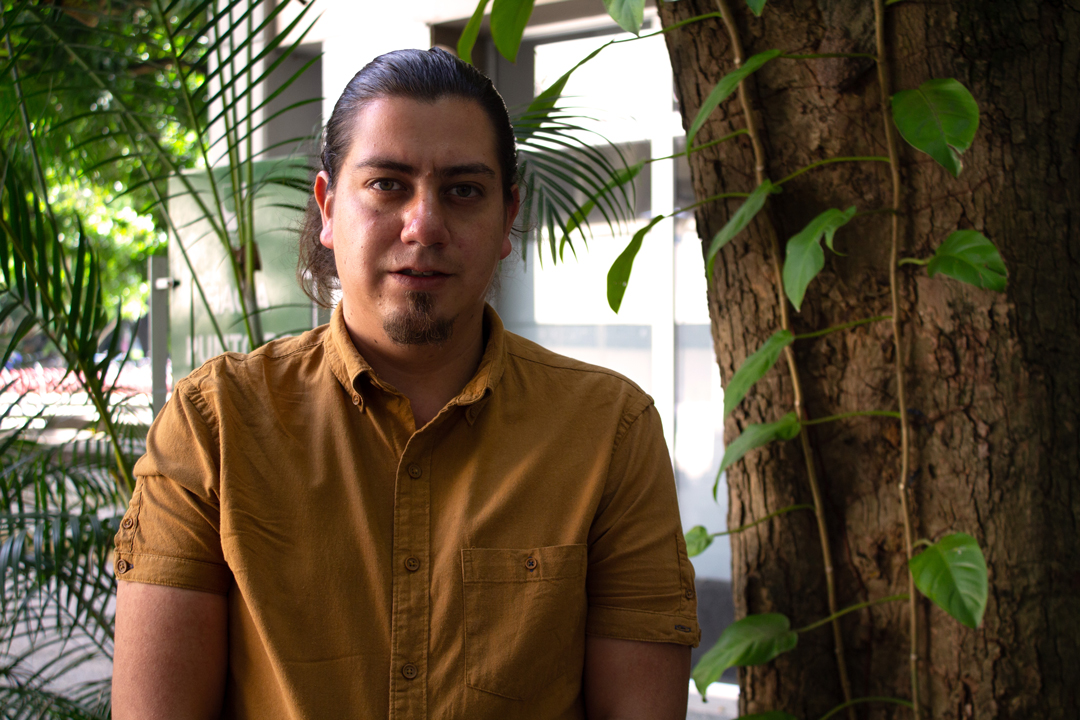
Daniel Mauricio Goyes Chaves, an engineering doctoral student with an emphasis in Industrial Engineering at Univalle, part of the Traffic, Transport and Roads Research Group (GITTV) and the Logistics and Production Research Group, described how researchers integrated various mathematical modelling techniques with the power of Geographic Information Systems (GIS) to analyse geographic data.
“Our research not only aims to optimise the logistics and quality of coffee, but also to improve conditions and opportunities for local farmers, thus contributing to the sustainable development of the coffee industry in the department,” said Goyes.
The Research
Goyes, originally from the municipality of Ipiales in Nariño, and a doctoral fellow of a programme of the departmental government and the Ceiba Foundation, explained that the basis of the study is the product of a doctoral macro-project that focuses on the strategic management of the specialty coffee supply chain in the department”.
This is a challenge in the 41 of the 64 municipalities where coffee is grown, with around 2,000 producers with farms ranging from 1,600 metres to 2,400 metres.
“In addition to this approach, we have also carried out a thorough analysis of the accessibility of producers in the region,” said Goyes, adding that Nariño is characterised by its complex transport network, whose layout is influenced by the high mountain topography and steep slopes that define the region.
“I have always been interested in territorial planning, especially when it is approached from a geospatial perspective and the analysis of geographic information in decision-making,” Goyes shared.
In addition, Goyes highlighted that he worked on this research with professors Carlos Alberto Arango Pastrana from the Department of Administration and Organisations at Univalle, as well as Ciro Jaramillo Molina, from the Faculty of Engineering at the same university.
“We used geographic data together with mathematical modelling, in particular, we applied infrastructure-based models to assess accessibility and connectivity conditions,” Goyes said.
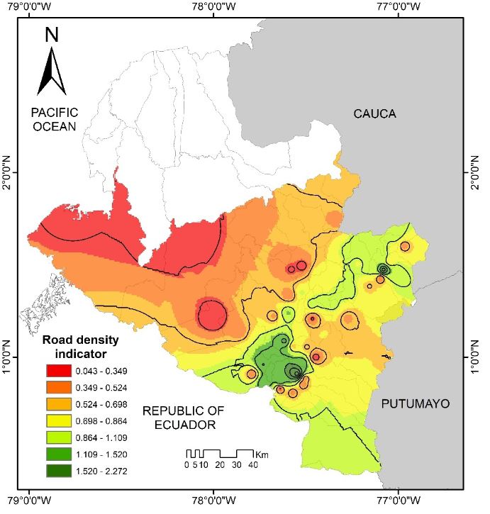
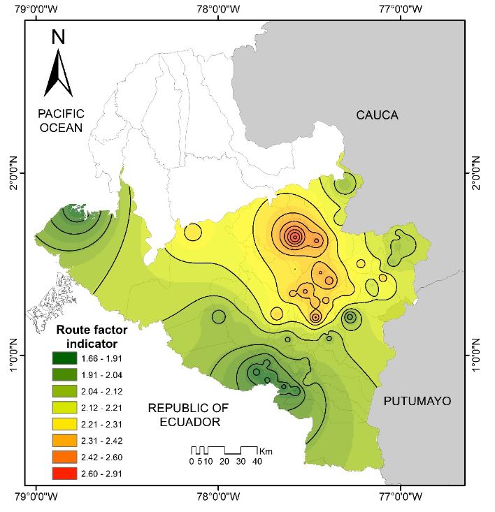
Los investigadores generaron dos mapas de superficies continuas y unas curvas que proporcionan una representación visual de los niveles de accesibilidad espacial en el departamento.
“We generate more than 3200 routes in the network between different nodes (64 municipal capitals), and then compare them with the most efficient route (Euclidean distances) in order to analyse the quality and efficiency of the network,” said Goyes, adding that another important factor that is possible to analyse is to identify alternative routes if there is a blockage.
Professor Jaramillo explained that the Road Density Indicator (RDI) is the ratio between the length of the total road network in an area and the total surface area.
“For example, the Tumaco area has very low density, since there are very few roads,” said Professor Jaramillo.
The Future
According to Goyes, the research carried out has a local focus, although our future vision is to be able to analyse and compare the situation of the department at national and international level, taking into account its proximity to Ecuador.
“The next step in the research involves the development of more advanced and effective tools focused on decision making regarding the planning and analysis of the department’s transport infrastructure, as support for transport ministries, the National Infrastructure Agency (ANI), the National Roads Institute (INVIAS),” said Goyes, adding that the researchers can model new scenarios, incorporating new connections between nodes and making a comparison with the baseline, represented by the existing infrastructure network.
Professor Jaramillo explained that they are already applying the same methodology to a new fourth-generation (4G) road in Nariño connecting the municipality of San Juan de Pasto and the Rumichaca international bridge.
“We can incorporate a new road and show the effect in the model,” said Professor Jaramillo, adding that they can also see what would happen if there are existing road restrictions to model the effects.
This article originally appeared on the Faculty of Engineering (Universidad del Valle) website here and was reproduced with permission. It is authored by Andrew James (NCC/Univalle).


